Nina Notman hears from the scientists trying to pierce the Earth’s crust below the seafloor to learn more about our home planet
‘This expedition will cost less than one single glittering missile blasting from the launching pads at Canaveral, and yet this project is as surely an adventure towards the discovery of a new world as were the three little lumbering ships of Columbus,’ John Steinbeck wrote in Life magazine in April 1961.
Steinbeck was reporting from a drillship during Project Mohole. The aim of this scientific cruise was to drill down into the floor of the Pacific ocean off the coast of Guadalupe Island, Mexico, to collect the first-ever sample from the boundary between the Earth’s crust and mantle. This region is called the Mohorovičić discontinuity, or Moho for short.
Project Mohole did not reach its target: it only succeeded in drilling a few metres into the basalt rock underneath the sediment on the seafloor. Nonetheless, the expedition was a major triumph for the scientific community. ‘They demonstrated the feasibility of drilling in deep waters in the ocean crust,’ explains Benoît Ildefonse, a geoscientist at the University of Montpellier in France.
The project – and the technology it developed – led to an international programme of scientific ocean drilling that has lasted over 50 years. This programme, currently called the International Ocean Discovery Program (IODP), has overseen more than 1500 boreholes being drilled into the Earth’s crust below the ocean for scientific research purposes, says Christian Berndt, a marine geophysicist at Geomar Helmholtz Centre for Ocean Research Kiel in Germany.
Under the sea
‘Drilling is the only possibility to really find out what is deep under the seafloor,’ explains Berndt. Most clues we have about the composition of the Earth’s crust, mantle and core come from observing our planet’s gravity and magnetic field, and watching how seismic waves travel through it. ‘But you don’t have proof that what you are interpreting in geophysical data is really true [until you] drill under the sea,’ Berndt says.
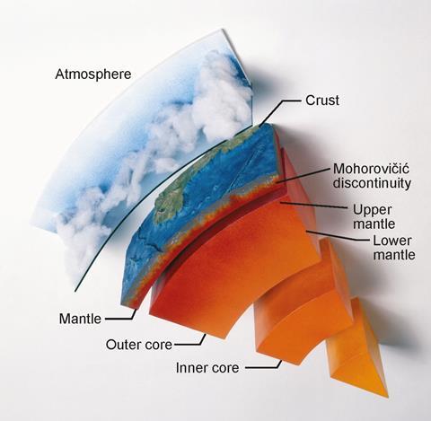
Drilling under the sea, rather than on land, might seem like an odd choice, but there is good reason: ‘This is where the Earth’s crust is the thinnest. It’s only 6km [thick] as opposed to several tens of kilometres on the continents,’ explains Ildefonse. Ocean drilling lets us ‘take a shortcut to reach the lower crust and the upper mantle a lot faster’, adds Sean Toczko, from the expedition project management team at the Japan Agency for Marine-Earth Science and Technology (Jamstec).
It’s a land-based drilling project, however, that holds the record for the deepest manmade hole. Scientists running the former Soviet Union’s Kola Superdeep Borehole project spent 24 years drilling a single 23cm diameter hole near the Russian border with Norway, reaching a depth of 12.26km before the project was mothballed in 1994.
Drilling down
No one has yet drilled down as far as the Moho, and consequently the mantle. The record for the deepest borehole drilled under the sea for scientific research is currently 3.25km. This was achieved in early 2019, at a site on the Pacific ocean’s Nankai Trough off southwest Japan.
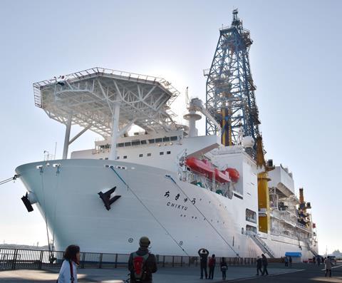
The scientific drillship Chikyu, Jamstec’s jewel in the crown, was used for this mission. Chikyu has been operating since 2007 and is 210m long – the same size as the largest ferry on the English Channel – and can accommodate 200 scientists, engineers and technicians. It holds state-of-the-art science laboratories and both a riser and non-riser drilling system.
Chikyu is the only ship used for scientific drilling that has a riser system, and it is this piece of machinery that opens up the tantalising possibility of successfully reaching the mantle. The riser drilling process has a number of additional components including the use of a pipe (riser) that connects the ship to the wellhead on the seafloor. ‘The riser drilling process creates a closed circulation system where the weight of the mud can be adjusted to balance the lithostatic forces of the surrounding rocks that are trying to close the open hole, therefore allowing deeper drilling than would otherwise be possible,’ explains Toczko.
During ocean drilling expeditions, copious amounts of data are collected from scientific instruments attached to the drill system. Additional instruments are also lowered into the empty hole after the drill is removed. Parameters measured include the density and porosity of the surrounding rock and its electrical resistance, which enables scientists to work out the type of fluid present there.
Sample scrutiny
Cores are also collected from parts of the Earth’s crust that are scientifically interesting. Chikyu’s coring system collects 9.5m of core at a time. ‘Once the sample is collected, the core barrel is pulled back up to the ship to recover the core, then a new empty core barrel is dropped into the drill pipe to continue coring,’ says Toczko. As soon as the cores are on deck samples of the gases being emitted from them are collected. They are then divided into smaller sections and taken to the ship’s laboratory.
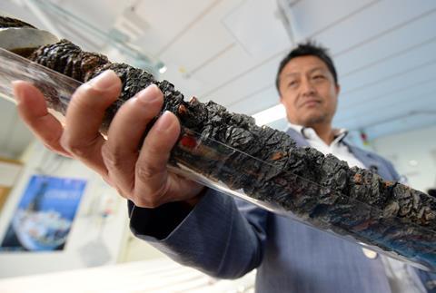
First, the core sections are put through a computed tomography scanner to check for any interesting internal structures worthy of closer inspection. Then, the scientists begin their analysis in earnest. ‘There’s a whole regime of work that goes on around the clock,’ Toczko says.
‘Inorganic and organic components of solid, liquid and gas phases of core samples are analysed on board,’ explains Harue Masuda, a geochemist at Osaka City University in Japan. ‘Analysed components include major, minor and rare earth elements, inorganic and organic carbons, methane, other alkanes, hydrogen and carbon isotopes,’ she adds. The scientists also carry out microbiological tests on the fluids and assess the chemical and physical properties of the minerals.
Cores are then frozen ready to be divided up between research teams for further analysis on shore at a later date.
Planetary treasure trove
60 years after Project Mohole, the dream of drilling down to get a sample of pristine mantle persists. ‘If we could get some pristine samples of the mantle, it would just be this treasure trove of planetary geology,’ says Damon Teagle, a geochemist at the National Oceanography Centre Southampton in the UK. ‘The mantle is the largest part of our planet by volume and by mass, but we don’t have any pristine samples of it,’ he adds.
For many elements, our estimates of their abundances are just guess work
Most of what we think we know about the mantle’s composition so far comes from geophysical observations. Clues have also been gathered from studying exposed (highly deformed and weathered) mantle found in a few locations on the seafloor, magma and volcanic rocks, and meteorites.
Scientists are particularly interested in quantifying heat-producing radioactive elements and volatiles such as carbon, sulfur, water and the noble gases. ‘For many elements, our estimates of their abundances are just guess work. People look at the composition of carbonaceous chondrites meteorites and make some rough calculations to work out what’s in the crust, and what is in the core, and then say “Well, the rest of it has to be in the mantle,”’ Teagle explains.
Nailing down the composition of the mantle would shed light on how our planet works. The carbon content, for example, would improve our understanding of the deep carbon cycle – the process of carbon cycling through the mantle and core of the Earth – and its role in controlling our planet’s climate.
The slow deep carbon cycle and the fast movement of carbon through the atmosphere and across Earth’s surface are intimately linked. ‘They interact at some points, especially at the mid-ocean ridges where mass exchanges between the hydrosphere and the rocks below in the crust and the mantle occur,’ says Ildefonse.
Scientists also want to quantify the mantle’s water content. ‘We do not know how much water is within the Earth but we think the mantle could be a major reservoir of water,’ says Susumu Umino, a geoscientist at Kanazawa University in Japan. The mantle’s water concentration determines its rheology and impacts how convection currents migrate through it. It is these convection currents that move the tectonic plates, causing earthquakes and volcanoes. Knowing the mantle’s water concentration would therefore allow scientists to better understand the causes of these geological phenomena.
Project Mohole take two
Unimo, Teagle and Ildefonse are all members of the organising team for the Mohole to Mantle project, the next planned mantle drilling attempt. Three potential drilling sites were identified about a decade ago: off the coasts of Hawaii, Baja California and Costa Rica. The choice between these three locations is still being made. Long timeframes are common for ocean drilling expeditions.
It’s not so much money to spend to know about some very key elements of our own planet
‘We are now waiting for several things,’ explains Ildefonse. ‘We’re waiting for more seismic imaging of the crust so that we know exactly where we want to go.’ New drilling machinery is also needed to survive high temperatures, and stronger and lighter drill pipes are required, he adds.
At some point the project will also hit funding issues, Ildefonse predicts. The Mohole to Mantle project is expected to cost about $350 million (£265 million). ‘Geologists are not familiar with spending so much money on a single project,’ he explains. To put the figure in context, Nasa estimates spending $2.7 billion on the Mars Perseverance rover project and $10 billion on the James Webb Space Telescope. If you look at it that way, Ildefonse says, ‘it’s not so much money to spend to know about some very key elements of our own planet’.
For those wanting to better understand earthquakes, the mantle is not the only location beneath the seafloor worth visiting. Places in the crust where two tectonic plates meet are also of high interest. The 2019 Nankai Trough drilling effort, which saw Chikyu’s drills reach the record-breaking depth of 3.25km, was actually aiming for a plate boundary fault buried over 5km beneath the seafloor. It was impossible to drill any further due to issues with the borehole collapsing, explains Masuda.
We want to touch the seismogenic zones and to understand what happens when an earthquake occurs
The Nankai Trough is one of the most active earthquake zones on Earth. Earthquakes are thought to occur when two moving tectonic plates get stuck together by friction and then suddenly separate, she says. ‘We want to touch the seismogenic zones and to understand what happens [to the rocks there] when an earthquake occurs,’ Masuda says. Identifying the rock and sediment structure in these regions would provide insight into their strength and frictional properties, as well as how they change in response to the stress caused by the stuck plates. This would help clarify the role of sticky tectonic plates play in causing earthquakes, Masuda says.
The sample collection attempt was a key element of the Nankai Trough Seismogenic Zone Experiment, also known as NanTroSeize. To date, this project drilled 80 holes in 17 different locations around the Nankai Trough. Nearly 5km of core have been collected, and numerous sensors – including seismometers, and temperature and pressure sensors – have been installed beneath the seafloor to record earthquakes in action. Plans are in the works to reattempt sample collection from the plates here too, says Masuda.
Put a Cork in it
The sensors in the Nankai Trough are part of a global network of over 30 borehole observatories installed in the ocean crust since 1991. The observatories are instrument-laden devices lowered into boreholes on the seafloor up to around 800m deep. They are called Circulation Obviation Retrofit Kits, or Corks. ‘The Cork is called a cork because they seal the top of boreholes,’ explains Evan Solomon, a marine geochemist at the University of Washington in Seattle, US.
‘Without scientific observatories, it’s like being an astronomer without a telescope,’ he says to outline the importance of Corks. Many modern Corks collect borehole fluids, along with temperature, pressure and other geophysical data. The fluid is collected very slowly, via osmotic pressure, through a valve into a long thin coil. ‘Now you have a time series of fluids in which you can measure whatever you want,’ says Solomon. Typical experiments involve analysing how the chemical composition of the fluid changes over time and in response to environmental perturbations and monitoring subseafloor microbial life.
Without scientific observatories, it’s like being an astronomer without a telescope
Corks have also recently started to be used for active experiments, explains Geoff Wheat, a marine geochemist at the University of Alaska Fairbanks, US. These include pumping geochemical tracers into surrounding rocks and tracking their onwards movements. By doing so, scientists can gather information about the direction and rate of fluid flow in the ocean crust.
Corks must be physically visited in order to start active experiments, collect fluid samples, and download data. Researchers visit them every two to five years, either by submarine or remotely operated underwater vehicle. ‘With the sub, you’re in a little ball that’s 6 feet 6 inches [2m] in diameter, so it gets pretty tight when you’ve got three adults in there and all sorts of instrumentation,’ explains Wheat. Typically, a trip to the bottom of the ocean lasts nine hours, with nearly half of that time spent travelling down and back up.
The most recently installed Corks were off the east coast of New Zealand’s North Island, at the Hikurangi plate boundary. Plate movement in this zone has caused a number of large earthquakes and tsunamis. Solomon was part of the team that installed the Corks in 2018, and then revisited them using a remotely operated underwatervehicle in March 2021, coincidently just a week after a series of nearby earthquakes. ‘We just received funding to visit the observatory and recover the downhole instrumentation in 2023,’ Solomon says.
Historical traces
The Chikyu isn’t the only ship used to deploy Corks, since a riser drill isn’t needed. The 143m long Joides Resolution,operated by Texas A&M University in the US, has been the workhorse for scientific ocean drilling since 1985. It has a non-riser drill and is used for the majority of ocean drilling expeditions, including the recent New Zealand Corks expeditions. The European Consortium for Ocean Research Drilling also occasionally hires commercial oil drilling vessels or platforms for scientific expeditions.
Joides Resolution’s most recent scientific expedition took place from August to October 2021, off the west coast of Norway. Numerous volcanoes were active in this area, called the mid-Norwegian volcanic margin, around 56 million years ago during a past climate change event. Geomar’s Berndt was one of the expedition’s chief research scientists. Twenty holes were drilled in nine different locations, he explains, with the deepest hole being 405m.
One of the scientific objectives of the cruise was to look for information about this ancient period of rapid global warming. ‘That was the last time that the climate warmed anywhere near as quickly as it is doing now, so it’s quite relevant to find out about geological and environmental process that were active during this kind of past warming,’ Berndt says.
Carbon sequestration
One of the objectives of that expedition was to look at whether the basalt under the seafloor in that region could be used to permanently store excess carbon dioxide produced by power stations and other sources of carbon emissions such as steel, cement and iron works.
Carbon capture and storage (CCS) projects typically store excess gas in disused underground oil reservoirs under impermeable rock layers. This type of storage will need eternal monitoring to check for leaks. An alternative approach gaining traction is to inject the carbon dioxide into basalt, where the gas reacts with the rock to form stable solid carbonate minerals.
Like trees and plants, basalt rocks naturally absorb carbon dioxide from the atmosphere so this type of CCS is just an accelerated version of a natural process. The mineralisation process takes around two years, and once complete, the carbon dioxide is locked away forever.
‘Basalt is the most common rock type on Earth,’ says Juerg Matter, a geoengineer at the National Oceanography Centre Southampton. ‘The ocean crust is basalt and you also find basalts on the Earth’s surface.’ CCS is not viable in every basalt rock, so in situ sampling is needed to check its suitability at potential injection sites.
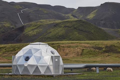
Permanent CCS in basalt has already been demonstrated at scale in a few locations, including the CarbFix project at the Hellisheiði geothermal power plant near Reykjavik in Iceland. Matter provides scientific support for CarbFix, which has been injecting carbon dioxide below ground since 2012. Up to now, all CCS injections into basalt have been land-based, but plans to do this at sea are on the rise.
Since Steinbeck set sail to cover Project Mohole over 60 years ago, a pristine sample of the mantle may still be proving elusive, but scientific ocean drilling has advanced beyond his wildest expectations. The boreholes drilled, and the Corks installed, have provided a treasure trove of information about the inner workings of our home planet. As well as delighting geologists, the discoveries have also had practical implications for better understanding earthquakes and other natural hazards that impact society, the habitability of Earth’s crust and the potential for live elsewhere, and Earth’s climate system with a potential solution to combat the climate crisis.
Nina Notman is a science writer based in Salisbury, UK


No comments yet